
The Effects of Urban Pollution: The Rouge Watershed
06/04/2019
Matthew Warner
Published by: Psytext
Introduction
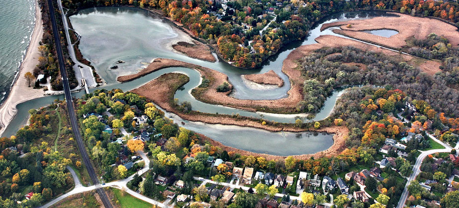
The Rouge Watershed
The Rouge Watershed. An important international water system that plants, animals and humans alike rely on . This international treasure is protected by the Rouge National Urban Park commission. This river and group of subsystems covers the eastern part of the Toronto, Ontario area before making its way southward.
1. Introduction: What is a Watershed?
2. Causes of Pollution
3. Pollutants in the Rouge Watershed and their Effects
a. Chloride Contaminants
b. Suspended Solid materials
c. Building Materials
d. Bacteria and Microbes
4. What is Being Done?
5. Conclusion
6. References
1. Introduction: What is a Watershed?
A watershed is a region of land that receives precipitation (usually from cities) and drains into a lake or an ocean. They usually consist of a number of streams that lead to central locations. Watersheds support various plant species, thus attracting wildlife as well. Depending on the area water is collected from, watersheds can contain both fresh and sea water.
The Rouge Watershed covers a territory of 336 km2, beginning from Oak Ridges Moraine in the North, all the way to the shores of Lake Ontario in the south. Land inside the Rouge Watershed is a blend of urban and agrarian areas. The Rouge and Little Rouge, are the two main rivers in the watershed, both of them starting at the slopes of the Oak Ridges Moraine and continue flowing south, before merging north of Highway 401 in the City of Toronto. A watershed network is designed to be able to provide us with vital ecological amenities, such as; safe drinking water (as mentioned previously) as well as recreational areas (such as swimming). These designated sections are where we can relax and view the beauty of nature. However, because watersheds are also very sensitive to pollution, it is quite easy for them to become contaminated due to the constant changing of land and political litigation, as seen in many urban areas. Urbanization also encourages surface runoff, causing water to become polluted with pesticides, fertilizers (if it flows through commercial farming areas) and road salt (if it flows through roads and streets). This will have a detrimental effect on the health of both the wildlife and ecosystem that depends on this water to survive. It also hurts the residents of the watershed region, who use this water for drinking and other activities.
2. Causes of Pollution
Urbanization is the reason behind many problems faced by humans, plant and animal life. Increased urbanization and its outcomes (roads, pollution) are and will keep on affecting our habitat. There are multiple causes of the pollution in the Rouge Watershed and it all started because of decades’ worth of human development. Our own growth is leading to an increase in the erosion of the region. Erosion has caused sediments to stack in the bottom of the streams, affecting marine life. These sediments carry particles that cause the beds of the streams to become more shallow, leading to a greater risk of flooding. Research has shown that the particles found in these sediments are those found typically in the material used for land development. The more we dump, the easier life becomes, but the harder it is to survive.
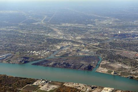
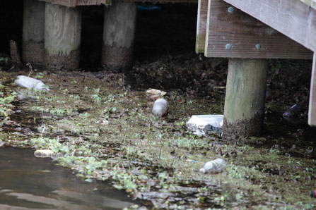
(Photograph published by: "International Joint Commission")
3. Pollutants Affecting the Watershed and their Effects
The Rouge watershed as of now has a ton of urbanization, achieving around 18-percent impermeable spread. There has been a tremendous upward example in ordinary yearly streams, with a typical augmentation of 1.3 percent consistently since 1962 (Noonan, 2016). The idea is credited in enormous part of the change in overflow from extended invulnerable areas related with present day improvement and not to climate capriciousness, as near examples are seen in other current watersheds and sub watersheds in the region anyway not in nation ones (Rouge National Urban Park, 2014).
A significant part of the wetland in the recreation centers have been drained to make way for agriculture. Farms are critical contributors of contaminants, such as bacteria and pesticides that get into the river systems. One in particular would be the dumping of unprocessed fecal matter. The Rouge River median concentration of phosphorus is around 0.02 mg/in the Little Rouge River and 0.05 mg/L in the Main Rouge, even though the provincial mandates say that it should be 0.03 mg/L.
Twenty-four golf courses have been built in the watershed region, making them major contributors of pesticides and unnecessary waste. Since golf courses require a lot of water, it can undermine the integrity of the stream.
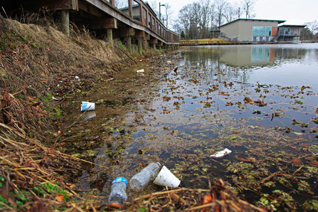
An examination of the spills in the Rouge park was conducted. From the information we found, between 1988-2000, there were about 300 oil spills and 90 chemical spills. The greater part of these happened around commercial plants, storage facilities, and trucks. A recent spill in the Little Rouge River killed all the fish, 4 kilometers in diameter. Contamination levels change significantly with water flow rates and volumes. These variations reflect contrasts in sources among dry and wet climates. Dry climate streams begin from groundwater, which has been separated by dirt and is regularly less polluted than surface runoff. Urban areas have groundwater runoff that goes into the climate stream. It might be increased by car washing, swimming pool use, and unintentional or intentional spills to basins.
Rural wellsprings of dry climate streams may incorporate crop water systems or stable areas. This would be despite the fact that these are regularly direct surface levels just in a roundabout way of expanding groundwater recharge. Most of the wet climate overflows in urban zones can't penetrate the water ways, because of the use of solid surfaces. This stops the wide assortment of contaminants from entering waterways. This quick streaming water gets microscopic organisms from untamed life and residential surfaces, supplements and pesticides from grass and patio nurseries, poisonous synthetic waste and a wide range of contaminants related to the transportation of land. When, including substantial metals, oil, oil, street salts and hydrocarbons. Climatic wellsprings of toxins, for example, particulate issue and polycyclic aromatic hydrocarbons (PAHs) are moderately more significant in urban regions than provincial, because of adjacent sources and the vast territory of impenetrable surface accessible to catch these pollutions. The streams related with urban surfaces have increased channel erosion, which adds to the dimensions of suspended solids and turbidity in the river system.
Right now, 35% of the Rouge River watershed is classed as urban. Since the mid 1990s, new improvements have been required to actualize stormwater amount and quality controls and where material channels rooftop spillover to grassed territories encompassing the house. Accordingly, around 60% of the urban zone has stormwater controls with amount and quality capacities. The remaining 40% consists of positive advancements in Toronto, Markham, Richmond and Stouffville. 55% of which have no controls and 45% have quality control only. The City of Toronto's Wet Weather Flow Management Master Plan (WWF MMP) epitomizes this new and cutting edge way to deal with stormwater. The board is looking at water and snow melting as an asset and embracing a treatment plan of approach that underlines the source control estimates first, trailed by movement and end-of-pipe controls.
a. Chloride contaminants
Chlorides from road salt are extending rapidly as urban improvement continues on the crucial piece of the Rouge. Back and forth movement levels in the midst of the winter speak to a threat to land and water proficient life in various bits of the watershed, especially downstream from high traffic districts. Unfortunately, stream storm water control estimates assume a restricted job in mitigating the issue since chloride does not progress toward becoming removed by lakes.
b. Suspended Solid materials
Groupings of suspended solids, metals, phosphorus and nitrates increase radically in the midst of times of wet atmosphere in light of overflow from urban communities and agrarian grounds. In around 40% of the advanced sectors, storm water is discharged clearly in the conduits without the treatment for water quality. In additional state-of-the-art urban zones, stormwater treatment measures are given. (Martin 1995)
c. Building Materials
Improvements are being made to the best crumbling and sedimentation points inside the riverbanks and the watershed in the midst of the season of land disturbance. The streams typically take longer hours to recover. Broken up buildup particles can pass on enhancements and diverse substances that are regularly found in the soil may have been created in the earth as a result of the increased improvement. The present usage of crumbling and sediment estimates, advancements and approval timelines are restricting the issue.
d. Bacteria and Microbes
The rates of Microbes inside the Rouge watershed exceptionally satisfy rules for contact with the body amid dry atmospheres in the midst of most of the seasons. At any rate, the shoreline is posted as hazardous for recreational exercises. It was recommended that infinitesimal organisms from close-by features (for instance Rouge Marsh) or possibly neighboring waterfront regions may impact water quality. A microbial after examination is starting now in Toronto to investigate the issue. (Keeler 1996)
4. What is Being Done?
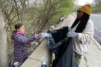
Many steps are being taken to address the urbanized pollution of the Rouge Watershed. In particular, the following is being done: In collaboration with local and national partners, such as Parks Canada Environmental, tree planting and stream bank enhancements have been created. TRCA works with local communities, such as Carolinian Canada to advance and secure endangered environments. TRCA will keep on working with Parks Canada to finish different natural reclamation projects in Rouge National Urban Park, including Sway Hunter Memorial Park. TRCA will likewise keep on working with nearby local groups to improve the indigenous habitat. For example, tree and wildflower planting, wetland creation, and untamed life living space preservation.
5. Conclusion
As society progresses, our demand for more amenities and naturally; the demand for more pollution removal systems, will grow, this will be coupled with detriment to our overall well-being and appreciation of our natural resources. But as time goes on, we also come to a better understanding of ways to deal with these issues, combined with technological advancements and our own personal ideas about the way we need to live.
References
Boyd, D., M. D’Andrea and R. Anderton. 1999. Assessment of Six Tributary Discharges to the Toronto Area Waterfront. Volume 2: Technical Appendix and Data Summary. Ontario Ministry of the Environment. Prepared for the Toronto and Region Remedial Action Plan.
Kaufman, Martin M. "COMMUNITY RESPONSE TO STORMWATER POLLUTION IN AN URBANIZED WATERSHED 1." JAWRA Journal of the American Water Resources Association 31, no. 3 (1995): 491-504.
Murray, Kent S., Linda E. Fisher, Jason Therrien, Bradley George, and John Gillespie. "Assessment and use of indicator bacteria to determine sources of pollution to an urban river." Journal of Great Lakes Research 27, no. 2 (2001): 220-229.
Pirrone, N. and Keeler, G.J., 1996. The Rouge River watershed pollution by trace elements: atmospheric depositions and emission sources. Water Science and Technology, 33(4-5), pp.267-275.
Ontario Ministry of the Environment. 1999. Surface Water Monitoring and Assessment: 1997 Lake Ontario Report. Queen’s Printer for Ontario, Toronto.